
Navigating the Most Dangerous Mountain Pass Frontier Crossings

The High-Altitude Sentinels: Famous Global Passages
When we look at a map, it’s easy to see a mountain range as a solid wall. But for the adventurous and the determined, there have always been "doors" in those walls. These mountain pass frontier crossings serve as high-altitude sentinels, watching over the flow of people and goods for millennia.
In the remote reaches of the Karakoram and Pamir mountains, the geography is as much a political statement as it is a natural one. These passes aren't just high; they are among the most isolated places on the planet.
The Roof of the World: Wakhjir and Khunjerab
If you find yourself at the Wakhjir Pass, you are standing at a truly unique intersection of geography and time. Located on the Afghanistan–China border at a staggering 4,923 meters (16,152 ft), it is the only potentially navigable pass between these two nations. Interestingly, it holds the record for the sharpest official time difference of any international frontier. When you step across, the clock jumps 3.5 hours (from UTC+04:30 to UTC+08:00).
Historically, this was a thread of the Silk Road. Even in 1906, explorer Aurel Stein noted it was used by about 100 pony loads of goods annually. Today, it remains a "silent" border; while road construction from the Afghan side reached the pass in July 2024, there is still no official border crossing, and military restrictions remain tight.
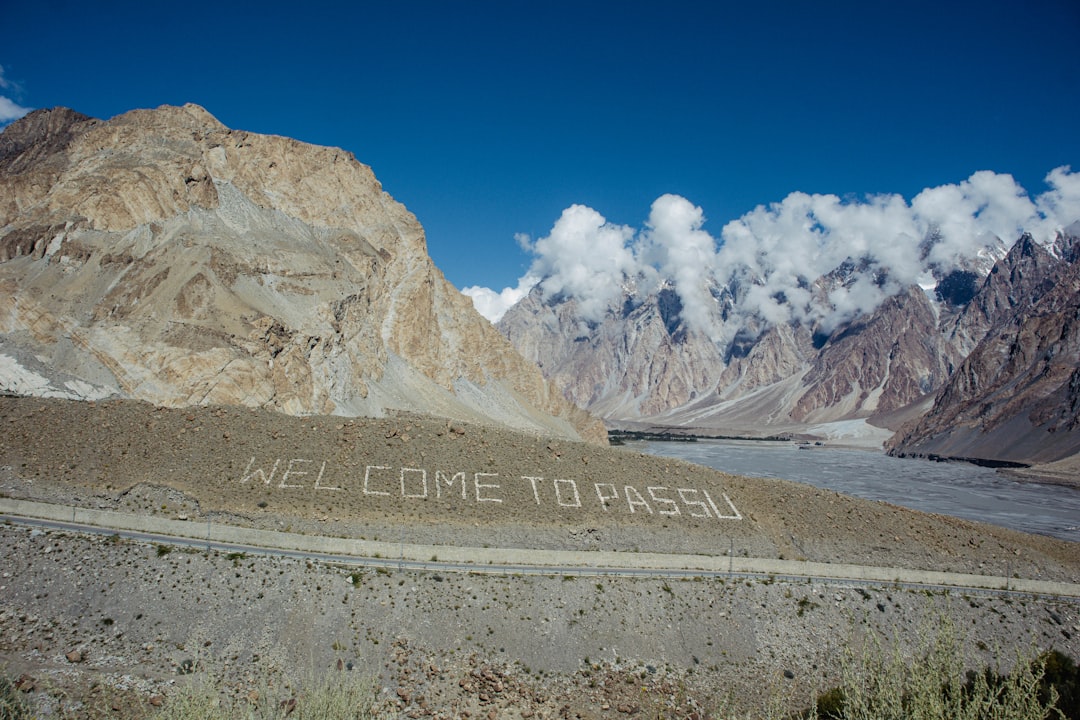
Further east lies the Khunjerab Pass . At 4,693 meters, it is the highest paved international border crossing in the world, connecting Pakistan and China via the Karakoram Highway. Its name translates to "Waterfall House" in the local Wakhi language. It’s a place of superlatives—home to the world’s highest ATM and a sanctuary for the elusive snow leopard in the nearby National Park.
Alpine Gateways: Brenner and Reschen Passes
In Europe, the Alps have been bridged by human ingenuity since the days of the Roman Empire. The Brenner Pass is perhaps the most famous. At 1,370 meters, it is one of the lowest and most accessible Alpine passes. It has seen everything from the marching boots of Roman legions to the 1940 meeting of Hitler and Mussolini. Today, it’s a bustling corridor where nearly 1.8 million trucks cross the Europa Bridge annually.
Not far away is the Reschen Pass. This pass is famous for a poignant sight: the 14th-century bell tower of the village of Graun, which still pokes out from the waters of the Reschensee reservoir. While the pass has been a trade route since the Roman Via Claudia Augusta in 50 AD, it became a formal border between Italy and Austria in 1919.
For those looking for a "secret" route, there is the Timmelsjoch . Known as the "secret passage," it bridges the Ötztal Alps. It was once the domain of the Ötztaler Kraxenträger—traders who carried flax, spirits, and livestock on their backs over the 2,474-meter summit.
PassElevationOpen SeasonHistorical UsePlöcken Pass1,357 mYear-round (mostly)Roman road; WWI frontKulma Pass4,363 mMay–NovemberSilk Road; modern tradeTimmelsjoch2,474 mJune–October"Secret" trade routeAbano Pass2,926 mMid-May–OctLocal Georgian transit
Echoes of the American West: Historical Mountain Pass Frontier Crossings
While the high peaks of Asia and Europe offer ancient history, the mountain pass frontier crossings of the United States tell a story of grit, hope, and the birth of a nation. For the pioneers of the 19th century, a mountain pass wasn't just a scenic viewpoint; it was the difference between a new beginning in the West or a tragic end in the snow.

The Great Migration: South Pass and Beyond
In the heart of Wyoming lies South Pass (Wyoming) - Wikipedia ). Unlike the jagged, terrifying peaks of the Alps, South Pass is a wide, gentle sag in the Continental Divide. To the early pioneers, it was a godsend. It provided a gradual ascent that wagons could actually navigate, making the Oregon Trail Stories of thousands of families possible.
When we think of American Pioneer Stories, we think of the resilience required to leave everything behind. Crossing the South Pass - National Historic Trail meant you had officially crossed into the "Pacific" side of the country. It was a moment of profound community—families would often camp together at the summit, sharing coffee and stories before the long descent toward the Pacific.
Further north, the Targhee Pass - Wikipedia and the routes mapped during the Lewis And Clark Expedition showed the sheer scale of the American wilderness. These explorers weren't just looking for a path; they were looking for a future. Every time they crested a ridge, they were expanding the definition of what America could be.
Modern Myths and Old Trails
Today, we look back at these routes with a sense of wonder. The Frontier Myth Today What The Old West Tells Us About Modern America reminds us that the spirit of the pioneer—the person who looks at a mountain and sees a challenge to be met—is still part of our national DNA.
We see this legacy in The First National Road Americas Original Highway To The Future. It was our first great attempt to stitch the country together through the mountains, proving that we are a people who value connection over isolation. At Patriot Dreams, we believe these stories are worth preserving. When you hear the audio of a pioneer diary while looking at a map of South Pass, the history stops being dry facts and starts being a heartbeat.
Beyond the Physical: The Digital and Cultural Frontier
The fascination with mountain pass frontier crossings has moved from the physical world into our digital culture. Whether it’s through the lens of a smartphone or the strategic map of a video game, these geographic chokepoints continue to captivate our imagination.

The Strategic Beauty of Mountain Pass Frontier Crossings in Gaming
In gaming, specifically the Age of Empires series, the "Mountain Pass" map reflects real-world geography with surprising accuracy. In Age of Empires II, the map creates a "nomad-style" start. Players begin with three scattered villagers in a snowy mountain landscape. There are no berry bushes or boars—only abundant sheep—forcing players to scout and adapt quickly.
In Age of Empires IV, the map is bisected by a massive mountain range, traversable only through narrow chokepoints. This mirrors how real-world passes like the Khyber or the Brenner functioned as strategic "gates" that could be defended by a small force against a much larger army. It teaches players the same lesson history taught the Romans and the Tush people of Georgia: control the pass, and you control the frontier.
Adventure Travel and Modern Frontiers
For the modern adventurer, these passes offer a different kind of thrill. Take the "Frontier Crossings" cycling route between Portugal and Spain. It’s a 58 km journey with nearly 1,000 meters of ascent. The route takes you through the village of Tourém—a Portuguese "peninsula" surrounded on three sides by Spain. It’s a place of stone houses and quiet cobbled streets where the border is almost invisible.
For those seeking more adrenaline, there is the Guadiana River zip line between Spain and Portugal—the only zip line in the world that crosses an international frontier. You can hurtle between countries at 70 km/h, skipping the immigration line entirely for 60 glorious seconds!
However, some frontiers remain rugged and dangerous. The Abano Pass in Georgia is often cited as one of the world's most dangerous roads. Reaching 2,926 meters, the 72 km road to the Tusheti region is a gauntlet of granite markers commemorating those who didn't make it. Local drivers often refuse to wear seatbelts, claiming they need to be able to "jump out" if the vehicle slips off the edge. It’s a stark reminder that even today, some mountain pass frontier crossings demand total respect.
Preparing for the Journey: Safety and Practicalities
If you’re inspired to visit a mountain pass—whether it’s a scenic drive through the Cascades or a historical trek in Wyoming—preparation is your best friend. The weather at high altitudes is famously fickle; a sunny afternoon can turn into a blinding snowstorm in minutes.
Essential Safety for Rugged Mountain Pass Frontier Crossings
When traveling through high-altitude frontiers, especially in winter, we recommend following the "slow and steady" rule. Here are some essentials for your journey:
- Tire Chains: In many mountain passes, carrying chains is a legal requirement during winter months. Practice putting them on before you’re stuck in a blizzard.
- Winter Car Kit: Always pack a kit containing a shovel, ice scraper, jumper cables, sand or kitty litter (for traction), and extra warm blankets.
- 4x4 Vehicles: For routes like the Abano Pass or remote parts of the Rockies, a high-clearance 4x4 vehicle (like the Mitsubishi Delicas used by Tush locals) is essential.
- Altitude Awareness: Passes above 3,000 meters can cause altitude sickness. Stay hydrated and don't exert yourself too quickly.
Navigating Modern Border Requirements
Crossing an international mountain pass today involves more than just a sturdy horse. You need to be aware of the practicalities:
- Identification: Always check the latest requirements from the U.S. Department of State. For U.S.-Canada crossings, NEXUS lanes can save time, but they have specific hours that vary by location (like Peace Arch or Pacific Highway).
- Hours of Operation: Many high-altitude borders, such as the Kulma Pass between Tajikistan and China, have strict seasonal and daily operating hours.
- Photography Restrictions: It’s tempting to snap an "Instagrammable" photo of a border stone, but many military-controlled passes (like those in the Pamirs) strictly forbid photography. Always ask before you click.
- Wait Times: Use real-time tools. For example, Washington State (WSDOT) provides electronic signs and cameras along I-5 to help travelers monitor border wait times before they reach the crossing.
Frequently Asked Questions about Mountain Pass Frontier Crossings
Can you legally cross the Wakhjir Pass between Afghanistan and China?
As of 2025, there is no official border crossing at the Wakhjir Pass. While there has been recent road construction on the Afghan side, the border remains closed to regular civilian traffic due to military restrictions and the extreme, "Great Game" era geopolitics of the region. It remains one of the most inaccessible frontiers on Earth.
What is the most dangerous mountain pass road currently in use?
The Abano Pass in Georgia is frequently ranked among the top ten most dangerous roads in the world. It is unpaved, prone to landslides, and open only from mid-May to mid-October. It requires a 4x4 vehicle and an experienced local driver who knows how to navigate the 2,926-meter ascent safely.
How did mountain passes shape early American trade?
Mountain passes were the "lifeblood" of early American expansion. Routes like the South Pass allowed the fur trade to flourish and enabled the The First Route 66 Road Trip How America Learned To Wander to eventually take shape. They allowed for the movement of people, ideas, and goods across the Continental Divide, proving that even the most formidable natural barriers could be overcome through pioneer resilience and community cooperation.
Conclusion: The Paths That Connect Us
At the end of the day, mountain pass frontier crossings remind us that we are a species of explorers. Whether it’s a Roman merchant 2,000 years ago or a modern family driving through the Rockies, we all share that same feeling of "what’s on the other side?"
At Patriot Dreams, we believe that these paths are more than just dirt and stone. They are the settings for the stories that define us—stories of kindness between strangers on a trail, the perseverance of families in covered wagons, and the shared heritage that connects us all.
By preserving these stories through audio and interactive maps, we hope to keep the frontier spirit alive for the next generation. After all, every pass we cross is a reminder that no matter how high the mountain, there is always a way through if we work together.
We invite you to explore your own family's "frontier" stories. Perhaps your ancestors crossed a pass to find a better life. Those stories are the true landmarks of our history. You can learn more about our mission to preserve these legacies at https://www.patriot-dreams.com/america-250-years-in-the-making.
Safe travels on whatever path you choose to follow. Remember to go slow, be kind to your fellow travelers, and always look back at the view from the top—it’s a perspective you won't want to miss.

Join the Patriot Dreams Community
Download the app today and start your journey through American history and personal legacy.

Explore Our Latest Insights
Dive into stories that shape our American legacy.